

NECO Geography OBJ
- A — 1:100,000
- A — 90°
- D — 100 m
- D — Nodal town
- C — Dendritic
- C — Pass
- C — Ijesa and Ketu
- B — Farming and trading
- D — 18.0 km
- E — Ketu
- D — Quartzite
- D — Lightning and thunder
- A — Atmospheric condition of a place
- E — 9.5
- B — Formation of crater lakes
- C — Glaciated highlands
- C — Saltation
- A — Contour ploughing
- E — Remote sensing
- D — High relief
- E — Rugged terrain
- A — Ibeno Beach
- E — Ship
- B — High importation of goods
- E — Ondo and Oyo
- D — External trade
- A — Brown card
- E — Venus
- E — 40°E
- E — Simple fold
- D — Syncline
- E — Troposphere
- D — Increase in the rays of the sun
- C — Dormant
- B — Drumlin
- E — Sand filling of wetlands
- B — Humification
- A — Afforestation
- A — Autodesk
- B — Iron ore
- E — Speedy movement of goods
- D — Production of consumer goods
- B — Bajoga
- A — Abundant grasses and short scattered trees
- B — Mangrove swamp
- E — II, III and IV
- B — Insecurity and banditry
- C — Promotes local industries
- E — Uneven development
- C — Large-scale production
- B — 30%
- B — 150,000,000,000 m
- B — Denudation
- C — Influence road construction
- E — Uses numerical values
- E — Size and texture
- D — Pixel
- D — Total population divided by land area
- D — Source of water
- D — Political instability
COMPLETED!!!
NECO Geography Practical and Physical
Number 1
(1a)
Answer loading…
(1b)
(i) Settlement: Settlements such as Gulu West are concentrated along roads and on relatively gentle land because such areas are accessible and suitable for constructing houses.
(ii) Agriculture: Farming is practised mainly on the gentle slopes and valley areas because the land is easier to cultivate and water is available from nearby streams.
(iii) Transportation: Major and minor roads link the settlements because they promote the movement of people, agricultural produce and other goods within the mapped area.
(1c)
Relief:
(i) The mapped area is generally undulating and hilly.
(ii) There are several isolated hills and highlands, as shown by the closed contour lines.
(iii) Some parts have steep slopes, indicated by closely spaced contour lines.
(iv) Gentle slopes occur where the contour lines are widely spaced.
(v) Valleys and lowlands occur between the hills.
(vi) The highlands form watersheds from which streams flow in different directions.
Drainage:
(i) The area is drained by several rivers and streams.
(ii) Most of the streams take their sources from the surrounding highlands.
(iii) The drainage pattern is mainly dendritic because the tributaries join the main streams irregularly like the branches of a tree.
(iv) The streams flow through valleys towards the lower parts of the mapped area.
(v) Some streams are tributaries which join larger rivers.
(vi) The presence of many streams indicates that the mapped area is fairly well drained.
Number 2
(2a)
The solar system is made up of the Sun and all the heavenly bodies that revolve around it, including the planets, their satellites, asteroids, comets and meteoroids.
(2b)
The Earth supports life because it has oxygen, liquid water and a suitable temperature, while Venus does not support life because it has an extremely hot atmosphere dominated by carbon dioxide.
(2c)
(i) Circumnavigation
(DIAGRAM)
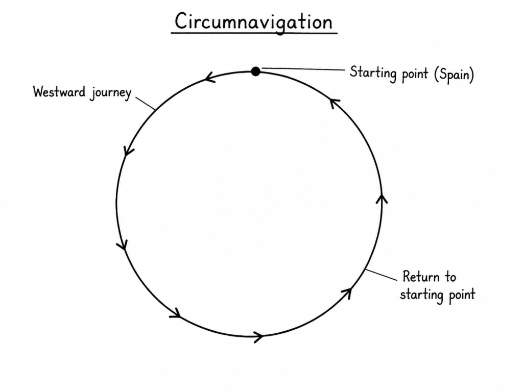
Circumnavigation is the act of travelling completely around the Earth and returning to the starting point.
When explorers travel continuously in one direction, either eastward or westward, they eventually return to the place where they started without reaching the edge of the Earth.
For example, Ferdinand Magellan’s expedition sailed westward from Spain and later returned to Spain from the east.
This would not be possible if the Earth were flat. Therefore, successful voyages around the world prove that the Earth is spherical.
(ii) Ship visibility
(DIAGRAM)
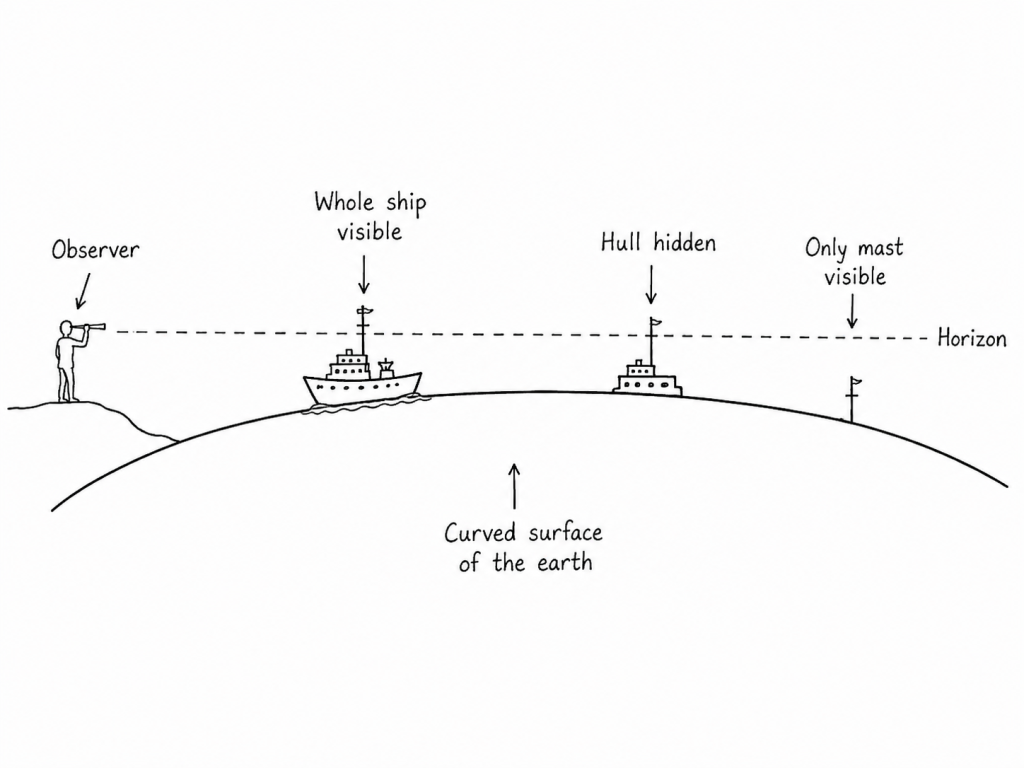
When a ship approaches the shore from a distance, the upper part, such as the mast and funnel, is seen first before the lower part of the ship.
When the ship moves away from the shore, the lower part disappears first, while the mast remains visible for some time.
This gradual appearance and disappearance of the ship occurs because the ship is moving over the curved surface of the Earth.
If the Earth were flat, the entire ship would appear or disappear at the same time. Therefore, ship visibility proves that the Earth is spherical.
Number 3
(3a)
(PICK ANY FOUR)
(i) A plateau is an extensive area of highland with a generally flat or gently undulating surface.
(ii) It rises sharply above the surrounding lowlands.
(iii) It may have steep sides known as escarpments.
(iv) Its surface may be dissected by rivers and valleys.
(v) It usually has an elevation of several hundreds of metres above sea level.
(vi) It may contain isolated hills, ridges and depressions.
(3b)
(PICK ANY FOUR)
(i) Agriculture: Some plateaux have fertile volcanic or well-drained soils suitable for growing crops such as tea, coffee, vegetables and cereals. The Jos Plateau, for example, supports the cultivation of potatoes and vegetables.
(ii) Livestock rearing: The cool climate and extensive grasslands of some plateaux favour cattle, sheep and goat rearing. The high elevation may also reduce the occurrence of certain livestock diseases.
(iii) Mining: Many plateaux contain valuable mineral deposits. For example, tin and columbite are mined on the Jos Plateau, creating employment and generating revenue.
(iv) Generation of hydroelectric power: Rivers flowing from plateaux descend steep slopes and form waterfalls and rapids. These provide suitable sites for constructing dams and generating electricity.
(v) Tourism and recreation: Plateaux often have attractive scenery, waterfalls, cool weather and unusual rock formations. These attract tourists and provide income to local communities and governments.
(vi) Settlement: The cool climate of some plateaux makes them suitable for human settlement. People may also settle there because of fertile soils, mineral resources and employment opportunities.
(vii) Water supply: Many rivers and streams originate from plateau regions. They provide water for domestic use, irrigation, industries and livestock.
(viii) Forestry: Some plateaux support forests which provide timber, fuelwood, medicinal plants and other forest products.
(ix) Communication facilities: The high elevation of plateaux makes them suitable locations for radio, television and telecommunication masts because signals can travel over long distances.
(x) Defence: The steep sides and elevated positions of plateaux may provide natural protection against enemies and make surveillance easier.
Number 4
(4a)
A fault is a crack or fracture in the Earth’s crust along which the rocks on either side have moved relative to each other.
(4b)
(DIAGRAM)
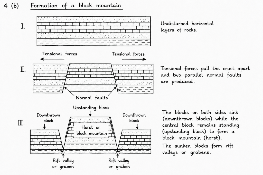
Formation of a block mountain:
(i) Tensional forces act on the Earth’s crust and pull it apart.
(ii) Two parallel normal faults develop in the crust.
(iii) The block of land between the two faults may remain standing while the blocks on both sides sink.
(iv) The central raised block forms a block mountain or horst.
(v) The sunken blocks on either side may form rift valleys or grabens.
Examples of block mountains include the Ruwenzori Mountains in East Africa and the Black Forest in Germany.
(4c)
(PICK ANY FOUR)
(i) Agriculture: Plains have level land and often possess fertile soils suitable for large-scale cultivation of crops.
(ii) Settlement: Their flat surfaces make the construction of houses, towns and cities easier and less expensive.
(iii) Transportation: Roads, railways and airports can be constructed more easily on plains because there are fewer steep slopes.
(iv) Industrial development: Plains provide extensive level land for the construction of factories, warehouses and industrial estates.
(v) Livestock rearing: Grass-covered plains provide grazing land for cattle, sheep and goats.
(vi) Irrigation: River plains provide water and fertile alluvial soil suitable for irrigated farming.
(vii) Trade and commerce: The high population and good transportation facilities of plains encourage markets and commercial activities.
(viii) Mechanised farming: The flat land allows tractors, harvesters and other agricultural machines to operate easily.
Number 5
(5a)
Height of mountain = 6,000 m
Temperature at the foot = 30°C
Normal lapse rate = 0.6°C for every 100 m rise
Temperature decrease:
= 6,000/100 × 0.6°C
= 60 × 0.6°C
= 36°C
Temperature at the summit:
= 30°C − 36°C
= −6°C
Temperature at the summit = −6°C
(5b)
(i) Air is heated mainly from the Earth’s surface: The Sun heats the Earth’s surface, and the surface then heats the air above it. Therefore, places near the ground are warmer than places at higher altitudes.
(ii) Air pressure decreases with altitude: At higher elevations, atmospheric pressure is lower. Rising air expands because of the reduced pressure, and the expansion causes the air to cool.
(iii) The atmosphere becomes less dense with altitude: The amount of water vapour, dust and other particles that absorb and retain heat decreases as altitude increases. Therefore, the thinner air at higher elevations holds less heat.
(iv) Distance from the heated surface increases: As altitude increases, the air becomes farther away from the main source of atmospheric heat, which is the Earth’s surface. This causes temperature to decrease.
Number 6
(6a)
(i) Cloud cover:
Cloud cover is the proportion of the sky covered by clouds at a particular place and time. It is estimated by observation and expressed in oktas, ranging from 0 okta for a clear sky to 8 oktas for a completely cloudy sky. Cloud cover influences temperature, rainfall and the amount of sunshine received at the Earth’s surface.
(ii) Sunshine:
Sunshine is the amount or duration of direct solar radiation received at a place. It is measured in hours using a Campbell–Stokes sunshine recorder. The duration of sunshine affects temperature, evaporation, crop growth and human activities.
(iii) Atmospheric pressure:
Atmospheric pressure is the force exerted by the weight of the atmosphere on a unit area of the Earth’s surface. It is measured with a barometer and expressed in millibars or hectopascals. Atmospheric pressure decreases with increasing altitude and influences the direction and movement of winds.
(6b)
(PICK ANY FOUR)
(i) Precipitation records help farmers determine the appropriate periods for planting and harvesting crops.
(ii) They help in planning irrigation and drainage projects.
(iii) They assist in predicting floods and droughts.
(iv) They help engineers plan the construction of dams, bridges, roads and reservoirs.
(v) They help determine the amount of water available for domestic and industrial use.
(vi) They assist in selecting suitable locations for particular crops and agricultural activities.
(vii) They help in planning hydroelectric power generation.
(viii) They provide information for weather forecasting and climate studies.
Number 7
(7a)
(PICK ANY FOUR)
(i) Indiscriminate logging for timber.
(ii) Clearing of forests for farming.
(iii) Bush burning.
(iv) Construction of roads, houses and industries.
(v) Mining and quarrying activities.
(vi) Collection of fuelwood and production of charcoal.
(vii) Overgrazing by livestock.
(viii) Population growth and expansion of settlements.
(7b)
(PICK ANY THREE)
(i) Soil erosion: Removal of trees exposes the soil to heavy rainfall and strong winds. The fertile topsoil is washed or blown away, thereby reducing soil fertility and agricultural productivity.
(ii) Loss of wildlife and biodiversity: Destruction of forests removes the natural habitats of plants and animals. Some species are forced to migrate, while others may become endangered or extinct.
(iii) Reduction in rainfall: Trees release water vapour into the atmosphere through transpiration. When forests are destroyed, less moisture enters the atmosphere, which may reduce cloud formation and rainfall.
(iv) Desertification: Continuous removal of vegetation leaves the land dry and bare. This encourages the spread of desert-like conditions, especially in areas with low rainfall.
(v) Increase in atmospheric carbon dioxide: Trees absorb carbon dioxide during photosynthesis. Deforestation reduces this absorption and may also release stored carbon when trees are burnt, thereby contributing to global warming.
(vi) Flooding: Forest vegetation slows down surface run-off and allows water to enter the soil. When trees are removed, rainwater flows rapidly over the surface, increasing the occurrence of floods.
(vii) Shortage of forest products: Deforestation reduces the supply of timber, fuelwood, medicinal plants, fruits and other valuable forest resources.
(viii) Destruction of the water cycle: The removal of trees reduces infiltration, transpiration and groundwater recharge, which may cause streams and wells to dry up.
Number 8
(8a)
Geographic Information System application is the use of computer hardware, software and geographical data to collect, store, manage, analyse and display information about places on the Earth’s surface.
GIS is applied in activities such as map production, urban planning, agriculture, transportation, environmental management, population studies and disaster control.
(8b)
(PICK ANY FOUR)
(i) High cost of equipment and software: Computers, scanners, digitizers, plotters, satellite images and licensed GIS software are expensive. Many government agencies and institutions cannot afford them.
(ii) Shortage of trained personnel: Nigeria has an inadequate number of skilled GIS analysts, cartographers, surveyors and computer technicians. This limits the effective use and maintenance of GIS facilities.
(iii) Inadequate and unreliable electricity supply: Frequent power failures interrupt data processing and may damage computers or cause the loss of important information.
(iv) Poor quality and insufficient data: Some available maps and geographical records are outdated, incomplete or inaccurate. This makes GIS analysis and results unreliable.
(v) Inadequate funding: Government agencies, schools and research institutions often lack sufficient funds to acquire equipment, train workers and update geographical databases.
(vi) Poor internet and communication facilities: Slow or unreliable internet service makes it difficult to obtain satellite images, share geographical information and access online databases.
(vii) Lack of regular data updating: Roads, settlements, land-use patterns and population figures change with time, but many GIS databases are not regularly updated.
(viii) Technical problems and poor maintenance: GIS equipment may break down because of poor handling, lack of spare parts and shortage of qualified technicians.
(ix) Low level of awareness: Some government officials, organisations and members of the public do not fully understand the benefits of GIS, resulting in limited use.
(x) Difficulty in obtaining information: Government agencies and private organisations may refuse to share geographical data because of security concerns, bureaucracy or poor cooperation.